
By Ashley Peterson
If you are still looking to get sendy even after temperatures have dropped and snowflakes have finally started to fall, keep reading to learn more about some fantastic winter 14ers!
My friend Greg and I took three days after Thanksgiving to tackle a trio of 14ers. We started with Mt. Sherman, which is considered to be one of the easiest 14ers. When we went, we were able to drive within 0.2 miles of the Fourmile Creek trailhead, which may or may not be the case if you go later in the winter.
The route is only 5.25 miles (child’s play for seasoned peak baggers, but still a fun little challenge, especially with snow) and gains 2,100 ft of total elevation so it’s pretty chill, not too strenuous, and fun: but for us it was WINDY.
The two groups of people that we passed who were descending while we were on our way up had turned around due to the windy conditions. Disclaimer: don’t ever venture too far past your comfort zone; you may not believe this in the moment, but the mountain will still be there even if you need to turn around and come back another day. I say “too far past” because hiking just outside your level of comfort is exciting and my favorite place to be (and its the only way to really grow as a mountaineer), but if you feel as though you are in imminent or significant danger at any point, that’s a great time to turn around.
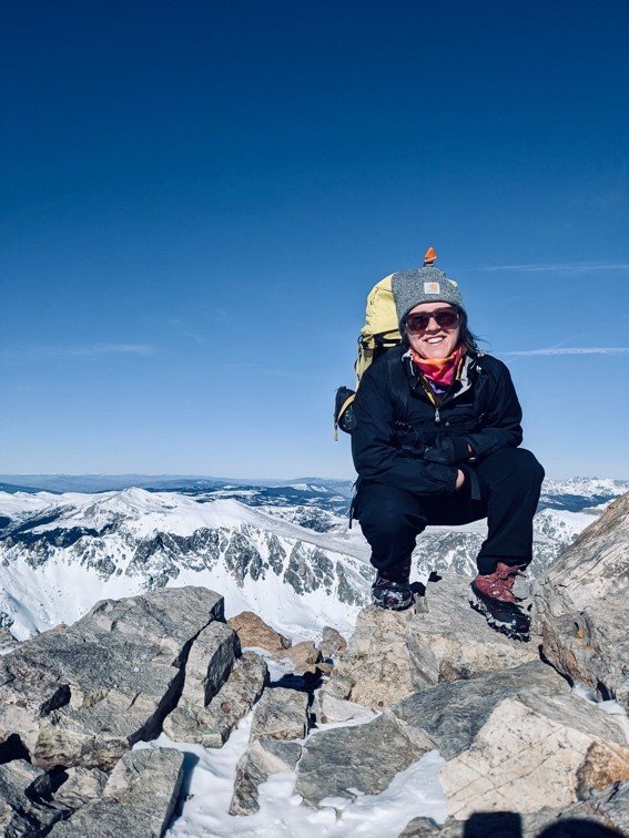
Greg and I talked about it for a moment, but then continued because we were still within our comfort zones. It was super cold, and the wind chill was intense, but we added extra layers (our big puffys) and reached the summit. I was not about to take my hands out of my gloves to take a photo, but luckily Greg did; he snapped a quick shot, and we began our descent, looking for solace from the wind.

There are a lot of old mining buildings and equipment towards the bottom of this route that are fascinating to examine during the ascent and descent. Back in the day, the Sherman Mine produced over 10 million ounces of silver, but hasn’t been operable for many years.
The whole hike took us less than 3 hours, even with a wrong turn at the beginning. Just past the mining equipment, there are footprints in the snow that go straight up, and ones that curve left, stay straight to stay on route. It’s windy and cold but the elevation gain is gradual, and the terrain never exceeds Class 1. After the hike, we grabbed dinner in Breck, and the following morning found us at the Quandary trailhead.
Everything you read says that Quandary is the best winter 14er due to minimal or nonexistent avalanche (avy) danger, a short hike, and expansive views of snow-topped peaks in any direction you look. I wholeheartedly agree that this is one of the best winter 14ers. The hike goes up the east ridge of Quandary, is less than 7 miles total and gains about 3,450 feet of elevation.
The trailhead is very easily accessible, and the route begins by meandering through trees with very gradual elevation gain. After a while, the trees become sparse, and the real climbing begins. There is quite a bit of rock to maneuver, but nothing over Class 1. The views from the summit were expansive: bright bluebird sky and snowcapped mountains visible in every direction. My head was on a swivel, not knowing which direction to cast my attention upon, afraid to miss out on something majestic.
On summits like this, you inhale deeply and feel as though you are breathing in air that has touched all the surrounding mountaintops. You feel like you are breathing in both the Sangres and the Sawatch.

For winter mountaineering, I recommend getting an early start by trudging uphill before the snow has had time to thaw. On the descent you will likely be sliding through slush and mud as temperatures rise with the sun. We wore microspikes on the way up but took them off shortly into the descent because they were getting caked in mud and were rendered useless.
Even on a Monday, there were several other people on the trail and that made the path even more sloppy. Overall, the Quandary hike was mellow and enjoyable, and at the time, I thought the views were unbeatable, until we reached Mt. Massive’s summit the following day.
Summit Post recommends the standard east slopes route up Massive for a winter approach, but we had just hiked 14ers the last two days, so we were hoping for something a little shorter than the 14+ miles of that route. The southwest slopes offered us a shorter route, although the trail ended up being longer than advertised.
The route up the SW slope is said to be just under 4,000 ft of gain and 7.25 miles. We couldn’t park right at the N. Halfmoon Creek trailhead after Greg nearly slid into oblivion in his Rav4, so we parked a little ways down the road. This unexpected snafu added a mile to our total. All in all, our GPS’ had us at about 9 miles and a little over 4,000 ft of gain. Nevertheless, it was an extraordinary hike; one of my favorites so far, with some of the best views!

We started hiking by headlamp, with our microspikes on, around 6 a.m. (it’s not summer anymore, Toto, and still dark at 6), trudging through trees and snow. As the sky began to lighten, we approached the beginning of the rockier section. There are stone steps available if you can follow the trail, and they make for a nice way to gain some real elevation.
Past the rock, we found ourselves on some long switchbacks in something of a melting-out meadow, the snow unable to hold out amidst all the direct sunlight on the south-facing slopes. Steadily gaining, we found more snow; in some areas we found steps kicked in by previous hikers, and in others we had to kick our own. Post-holing (stepping through the crust and each leg plunging down vertically and getting buried in snow) didn’t happen super frequently on the way up, but once the snow was softened by the sun, we found ourselves breaking through the crust regularly.
There are a handful of quite deceptive false summits on this route. The first one was a little defeating and Greg asked if we could call it there, but I quickly informed him that was not an option, and we continued. The snowy, rocky, ridge walk to the summit turned out to be my favorite part of the whole climb, and Greg agreed, happy I didn’t let him throw in the towel.
I felt like I was in a snow globe (but the lame kind where there’s no actual snow falling from the sky) because of the 360-degree picturesque views of clear blue sky and shimmering, snowy peaks. On some distant mountain ranges, we could see a vertical line of snow across the range, and other peaks were so near to us that we could make out the jagged, steep cliffs that grant each mountain its unique character.

I wanted to stay and admire that view forever, but after making it past all the false summits and spending a few minutes in sheer awe of the cloudless, bluebird day and the freshly whitened peaks in every direction, we reluctantly made our way back down.
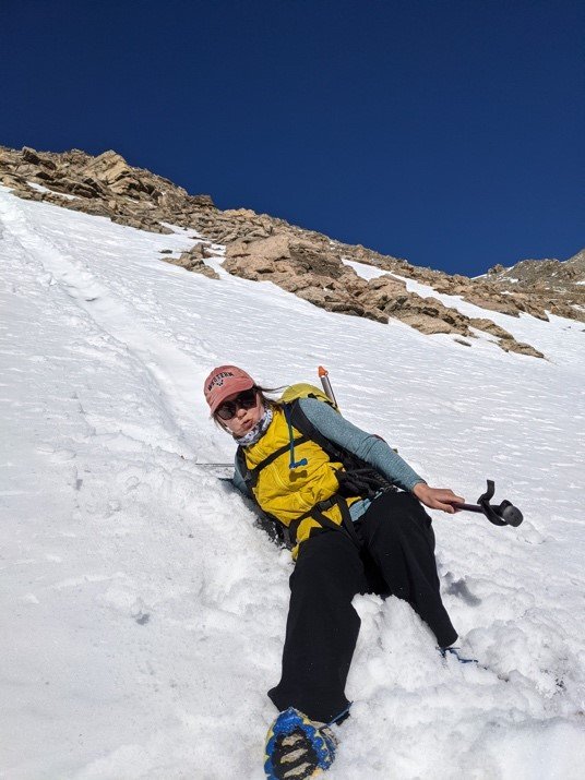
We slipped a few times in the slush and opted for one little purposeful glissade (snow slide; pictured below), before making it down entirely intact. Finally, back at the car, it was 3 p.m. and it had taken us 9 hours to go 9 miles, but it was worth every minute. Massive was a great end to our three days of 14er peaks, each one getting a little more challenging with a slightly better view.
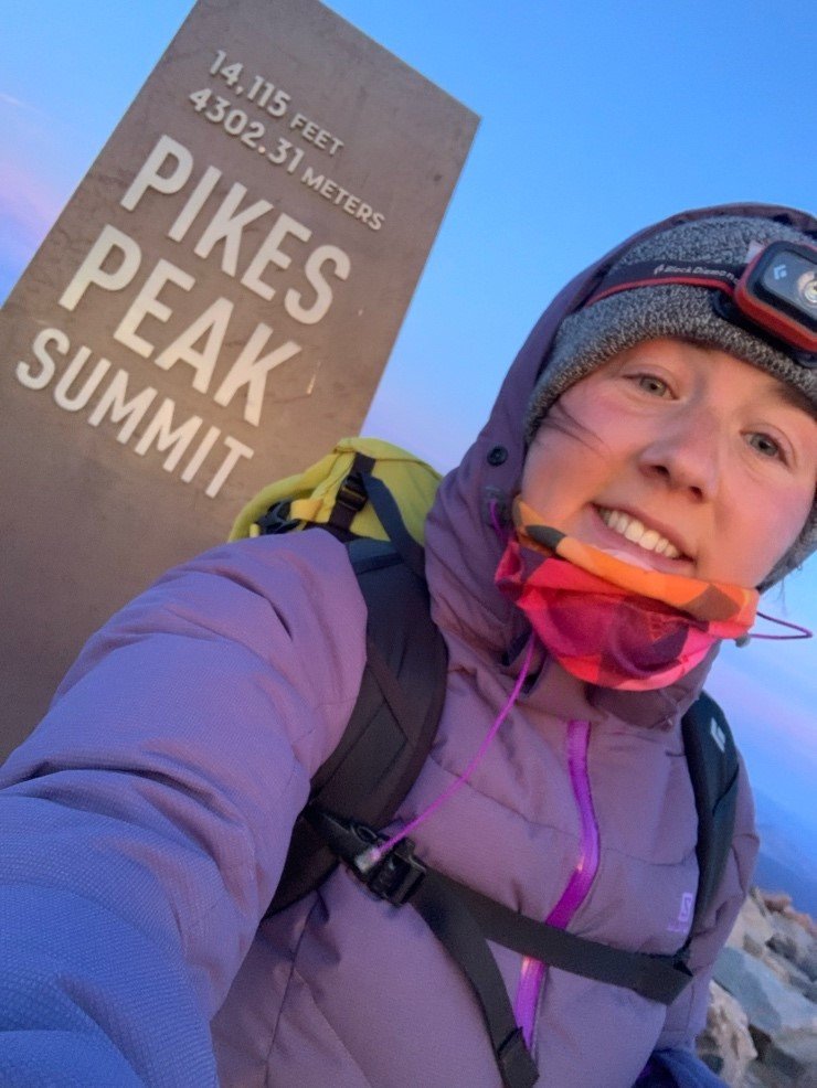
Pikes Peak also lends itself as a solid winter 14er. I completed this peak as my 30th Colorado 14er summit in 30 weeks! I started from the Crags Campground, which is not the standard route. The standard route begins at Manitou Springs, is Class 1 and is a whopping 24 miles long with a strong 7,600 ft. of gain. The route I chose to do is up the northwest slopes, Class 2, 14.5 miles and a lesser but still significant 4,500 ft. of gain.
I left Gunni just after midnight, got to the trailhead around 3 a.m., and started the hike shortly after by headlamp. I think I’ve previously mentioned that hiking by headlamp is one of my favorite things; hiking in the dark is “free” miles, and it makes an out-and-back hike more interesting on the descent because you haven’t seen your surroundings in the light yet.
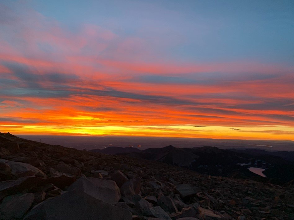
Plus, trying to time your movements so that you make it to summit close to the time of sunrise is a fun little game to play. Hike too fast, and you’ll spend too much time at summit in the cold and dark waiting for the sun. Hike too slow, and you just might miss the sun rising all together! I like to check and see what time the sun will rise and try to be about 10-15 minutes ahead of that to enjoy the sherbet sky for a few minutes before the sun makes its dramatic appearance.
As soon as I got above treeline, the wind was whipping and so intense. Every step I took, I felt like I was stepping through waist-deep water: the wind resisted my every attempt to move forward. But I put on every layer in my backpack (something I have never needed to do before) and trudged along, shoulders hunched and head down, zipping all possible zippers and pulling all my layers tighter.
I even found myself on the road a little bit to avoid a windy ridge. This maneuver bumped up my total mileage from 14.5 to nearly 16, but it was a definite must for me. The whole hike required about 7 hours.
There was hardly any snow, especially up high, and I never felt the need to put on my microspikes. I was, however, happy to have my trekking poles with me to help keep me upright whenever the biggest gusts came. If anyone saw me coming, they might have thought they were seeing an archaic witch, walking carefully, hunched over, leaning heavily into her cane (poles) for stability.
I made it to the summit a few minutes before sunrise, just how I like it, and what a colorful sunrise it was! Sunrises like this make it worth waking up at midnight. The hike down was windy but uneventful with spectacular views.
Winter 14ers can be a blast and I’ve found the views to be better than in the summertime, but winter certainly carries its own dangers as well. Be prepared with base layers, several additional layers, trekking poles and microspikes or crampons on waterproof boots. I’ve still been using my Camelbak, but keeping the hose in my shirt so it stays warm enough to drink from, otherwise, you may want to switch to water bottles because they won’t freeze in your pack.
Pay close attention to the weather and the avy danger for the area you are going. 14ers.com and summitpost.org have some valuable information on 14er peaks and their winter risks.
Risk, in an acceptable amount, adds to the excitement of mountaineering and increases your skill level, but excessive risk should be mitigated, and if it cannot, should be avoided altogether. Be smart and be safe out there.
Happy sending!