
By Ashley Peterson
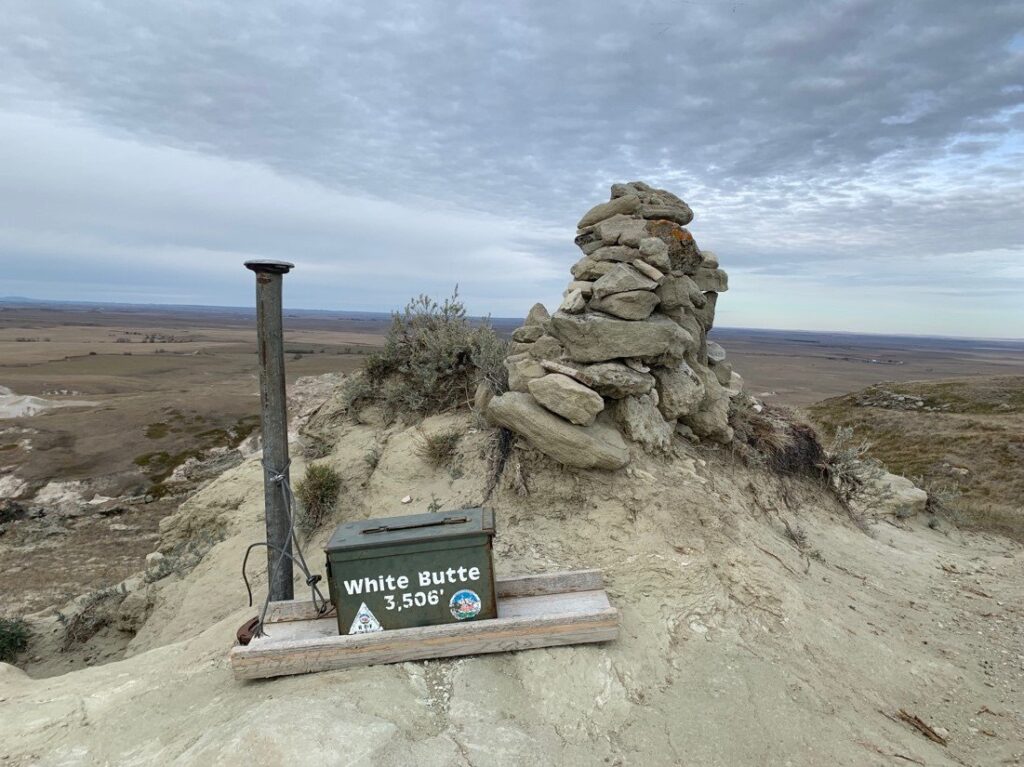
After my week back in Oregon, I headed straight east until I reached North Dakota and White Butte (3,506’), the highpoint of North Dakota. White Butte get its name due to the physical characteristics of the mountain; the white rock and soil contain bentonite, which is a type of clay formed typically from volcanic ash.
This was a very chill hike, relatively flat and only a few miles in total. I mean, I did it in Vans. So that’s saying something. Pretty cool though. I’d never been to North Dakota, and it was great to experience a little of the land there.
South Dakota’s Black Elk Peak (7,244’) was the shock of the century! Other names for this mountain top are Hiŋháŋ Káǧa (‘owl-maker’ in Lakota) and Heȟáka Sápa (‘elk black’). This peak is the highest elevation east of the Rocky Mountains until you reach the Pyrenees in France. It was an incredibly cool hike. The trail was just a little over 7.5 miles, the elevation gain was about 1,500’, and it took me about 2.5 hours. I started in the dark as snowflakes started to fall. Near the top, you go through a cave to some metal staircases before reaching this really cool lookout tower. There was no view, only dense fog, but the location and hike were well worth it.
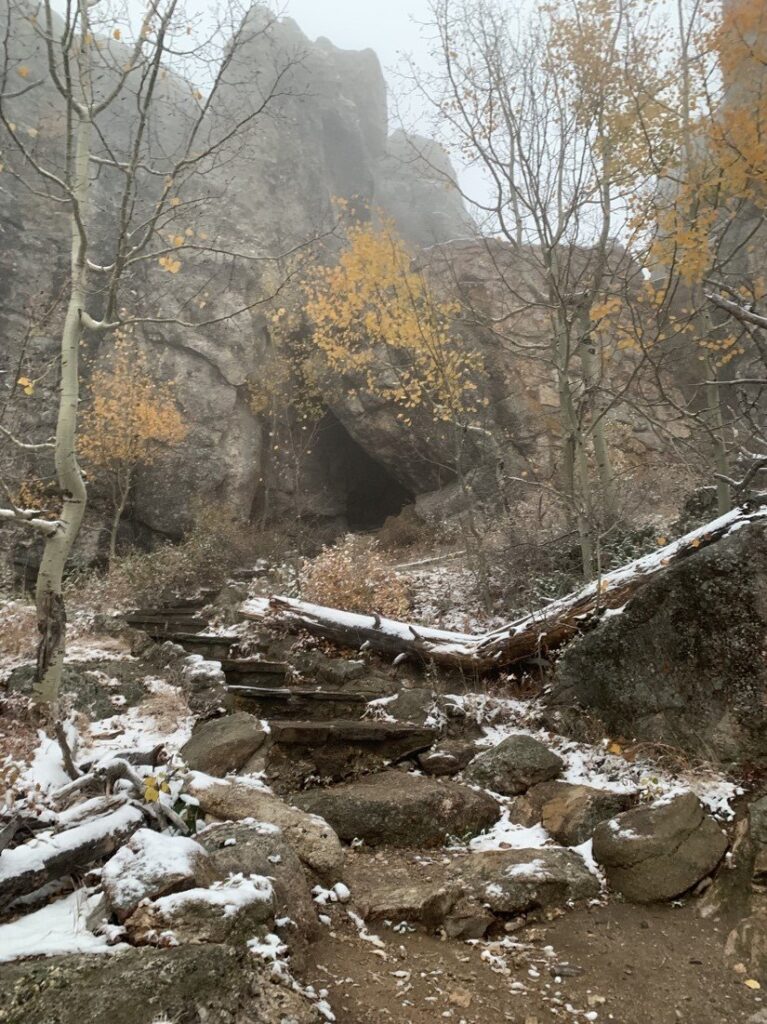
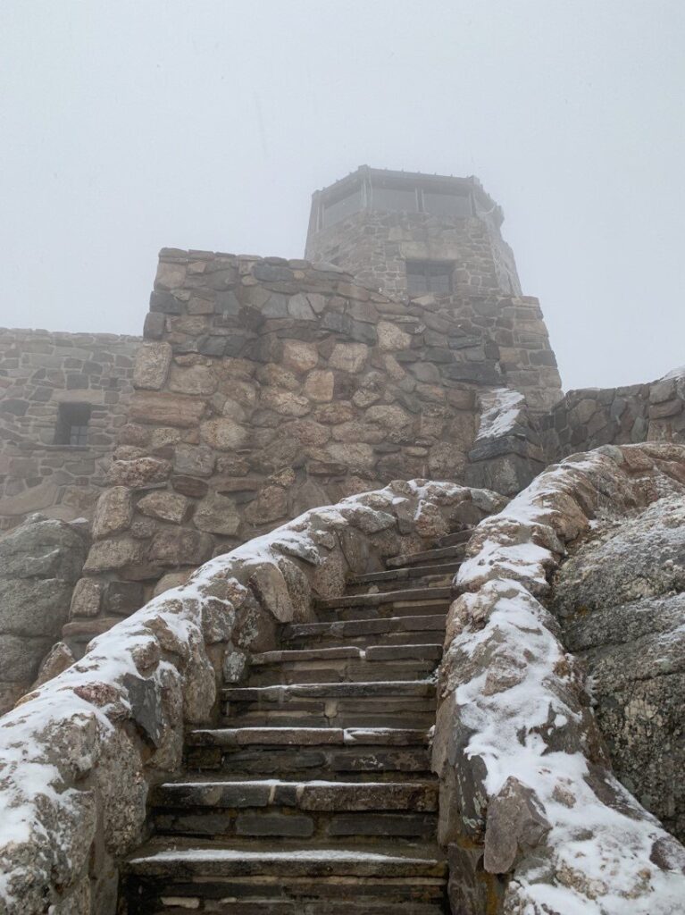
It was a beautifully eerie hike. I loved it.
Nebraska’s highpoint (5,424’) is in the middle of the High Point Bison Ranch. You drive right up to it. At least it was a beautiful day. I did decide to make it a little more interesting by busting out the unicorn fit.

Next up was Oklahoma and Black Mesa (4,973’). Black Mesa is a mesa that crosses into Colorado, New Mexico and Oklahoma. Quite a bit of wildlife can be found in this shortgrass prairie ecosystem, including mountain lions, butterflies, and the Texas horned lizard. The hike is 8.5 miles with less than 1,000 ft. of total elevation gain. The hike was colder than anticipated, but I should have started to assume that would be the case, as it was October after all. But it was beautiful. I certainly felt like I was getting into the plains; not too many trees to be seen.
After Oklahoma, I went to Arkansas for Mount Magazine’s Signal Hill at 2,753 ft. There is some speculation as to the accuracy of this, but English botanist Thomas Nuttall, wrote in 1819 that French hunters named the mountain “Magazine” or “Barn” (French magasin) because of its “peculiar form”. The hike was about a mile and a half in a forest. It had hardly any elevation gain and since you’re in a forest, there was really no view at all.
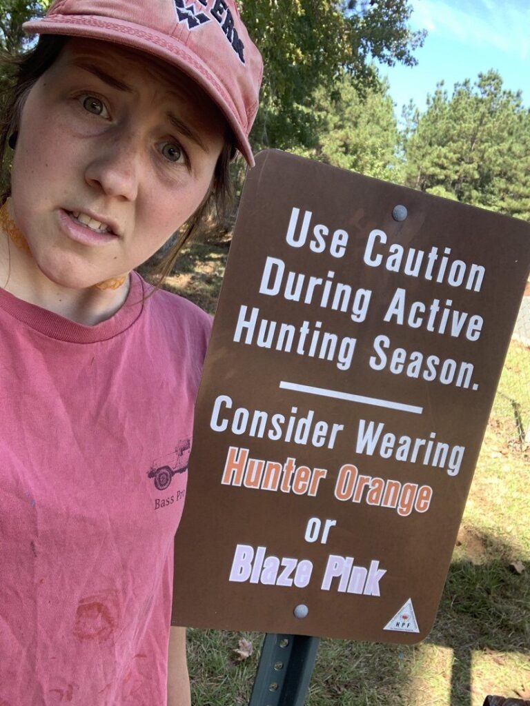
That same day, I drove to Louisiana’s highpoint, Driskill Mountain (535’). Although the highest natural point in LA, there are two buildings in New Orleans that reach higher than the top of this “mountain”. You would have to stack 38 Driskills on top of each other to reach the height of Denali!
It was largely the same thing, about a 2-mile hike, not much gain, but in a very different forest. This hike, as many are, is on private property and so you’re asked to be courteous and not litter, but come on, don’t do that regardless! Less standard was a sign at the trailhead that read, “Use Caution During Active Hunting Season. Consider Wearing Hunter Orange or Blaze Pink”. After seeing so many hunters only hours earlier in Arkansas, I donned the most similar things I could find in my car, mostly just red, including my iconic Western hat, and went on.
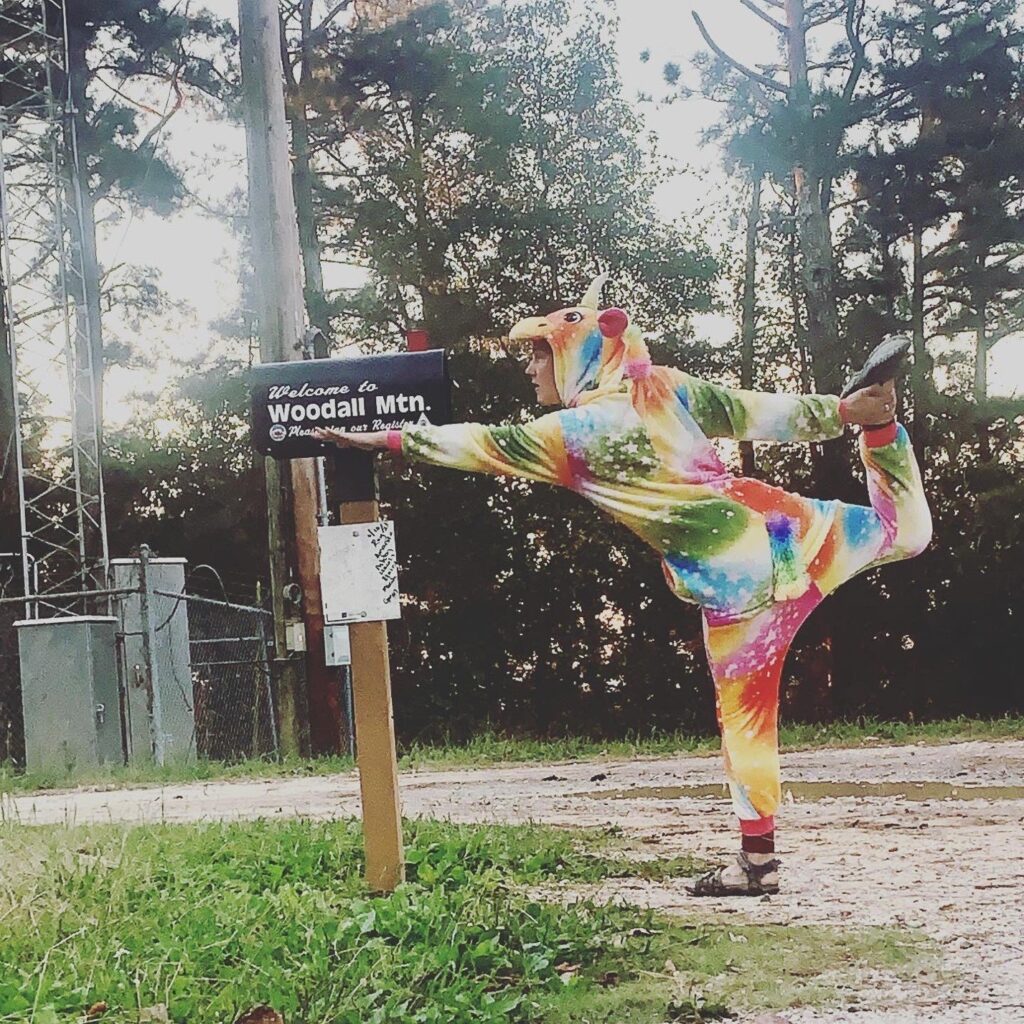
Next on the list is Mississippi and Woodall Mountain (806’). Woodall Mountain was a sight of fighting during the American Civil War; on September 19, 1862, the Battle of Luka took place here.
This one is another drive up. So of course, I put the unicorn onesie on again and took a sweet photo, signed the register, and drove to Alabama.
Alabama’s highpoint is Cheaha mountain in Cheaha State Park. There is a Civilian Conservation Corps tower at the top named Bunker Tower. The juxtaposition between the musty insides of a dark tower and the brilliant sun shining right outside, made my moment in the tower extremely brief. It sits at 2,401 feet above sea level and is another drive-up but can also be done as a hike.
I opted for the hike; it was honestly quite strange. It’s like they thought the highpoint should be a hike and not a drive, so they threw a few trails together, connected by road, to make a hike to the highpoint, or at least that’s what AllTrails did. But the woods are pretty colorful there this time of year. The hike was super easy to follow in some portions, and not so easy in others; I got off trail pretty bad a time or two. The trail I did is called “Cheaha Mountain via Lake Trail” on AllTrails. It says it’s a little over three miles in total. Hard to say how accurate that is because I went severely off route at one point. Amazing views and a decent hike.
I slept at the coolest rest stop I have ever been to, between Cheaha and Lakewood Park. This park, and Britton Hill, is Florida’s highpoint. 345 feet, making it the lowest of the U.S. highpoints. I got a sweet sunrise, had a nice jaunt around the park, and set off for Georgia.

Georgia’s highpoint, Brasstown Bald (4,784’) is a drive up as well. Its Indian name, Itseyi, means “a place of fresh green,” which refers to the grassy, treeless summit. Early white settlers mistook the Indian name for a similar one which means brass.
Although a drive-up, you can also hike it, if you feel so inclined, which I did. The route I did was called “Brasstown Bald via Jack’s Gap” on AllTrails. The app says it is a little over 6 miles and 2,200 ft. of gain, and my Strava concurred. My biggest complaint is that right at the start, out of nowhere, a bee came and stung my arm! It royally hurt and even a couple of days later, it still did. The first 2.5 miles were very uncrowded, but then you walk across a parking lot to the visitor center to hike up the rest of the now-paved trail with the masses. The views are well worth the tourist jostling.
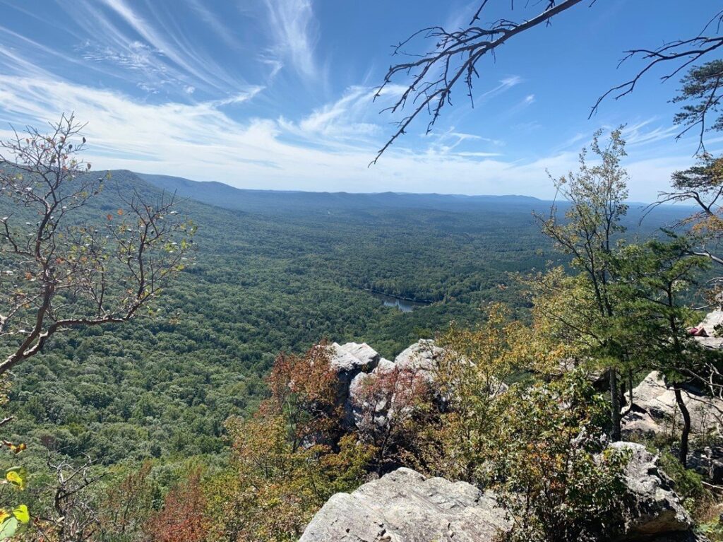
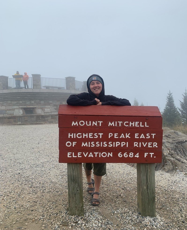
It is only 2.5 hours from Brasstown Bald to Sassafras Mountain (3,566’), South Carolina’s highpoint. It gets its name from the countless sassafras trees that grow along its slopes. I had a hike that I had planned to do here. But I got sick, so I took the drive-up option and made it in time for a beautiful sunrise. Then it is another 2.5 hours in the car, and you reach Mt. Mitchell (6,684’), known in Cherokee as Attakulla, is the highest peak in North Carolina and the highest peak east of the Mississippi. It is in the Black Mountain range of the Southern Appalachians and is part of a mountain system that has some of the oldest and most complex geological formations on earth.
The drive was incredible, so many fall colors and leaves blowing from the trees. It was so foggy though that there was no view from the summit, but in my sickened state, I honestly didn’t really care. The fog is pretty on its own, anyway.
Less than a 3-hour drive from Mt. Mitchell is Tennesse’s highpoint, Clingman’s Dome, at 6,643 ft. Its name in Cherokee is Kuwahi, meaning “mulberry place.”
I had a sweet 18-mile hike planned, but alas, opted for the 1-mile trail. SAD DAY. I got there just after the sun went down and the fog was so thick, I could barely see another person until they were just 5 feet in front of me. But I took the path anyway since I knew it was short. I rushed up it, saw nothing but fog and the ghostly silhouettes of a few trees, and tromped back down, making it my third highpoint in a day.
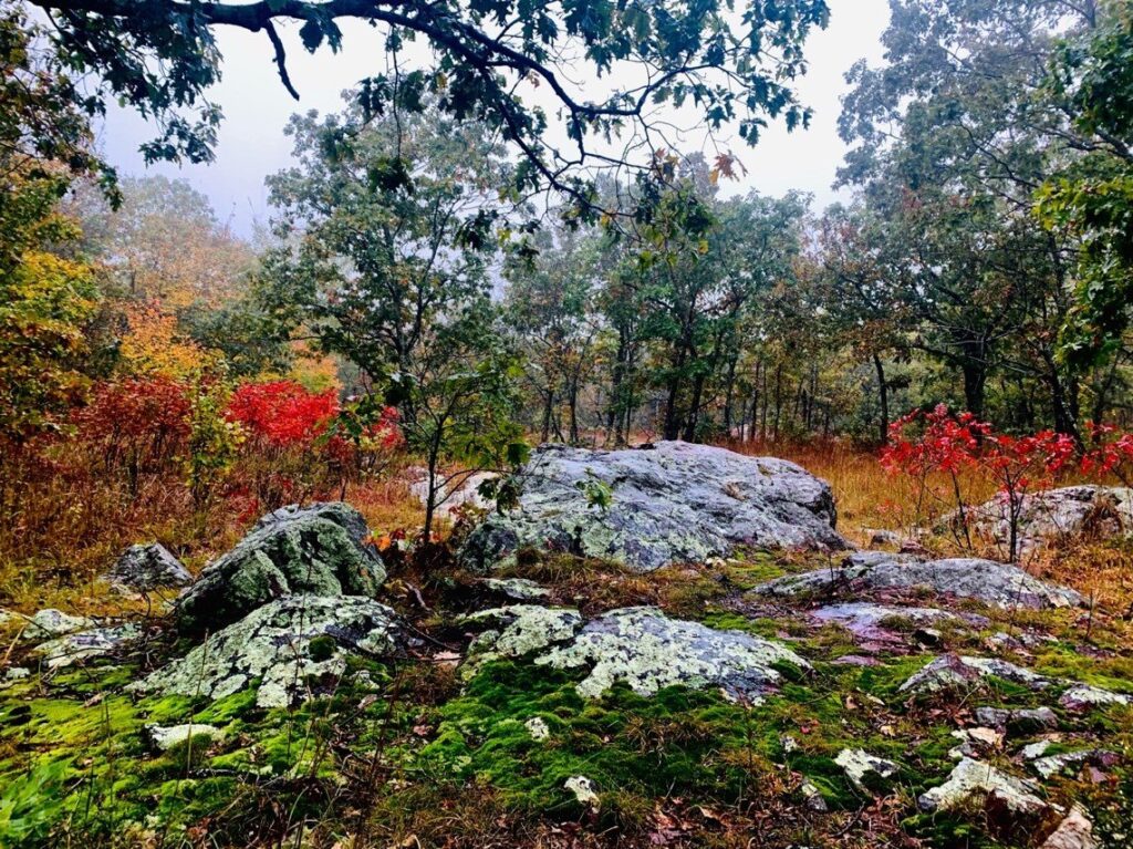
I easily did South Carolina, North Carolina, and Tennessee all in a day due to my lack of hiking ability. Now the longer driving starts again to make it to Missouri’s highpoint. Taum Sauk mountain (1,772’) is named after a Piankeshaw chief named Sauk-Ton-Qua. It isn’t much of a mountain in the traditional sense, and the “summit” is on a 0.2-mile paved path through some glorious fall-colored woods. There is a 2 mile out-and-back trail that can be done but it was pouring rain and I was still sick. The rain added a freshness to the leaves that brightened their reds and yellows. Uneventful, but incredibly beautiful.
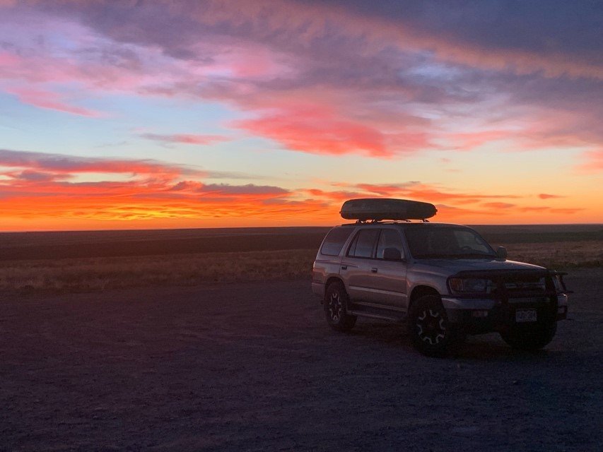
Another long drive got me to my last highpoint for the trip, #19, Mt Sunflower (4,039’), the highpoint of Kansas. The name comes from Kansas itself being the “Sunflower State”.
I got here just before sunrise and much to my delight, the expansive horizon was decorated with swirls and whisps resembling all my favorite colors of cotton candy. The sky looked oh-so-sweet, and I sat in blissful wonder as the sun eventually made its appearance. This highpoint is in the middle of a working cattle ranch, so the cows abound. But the owners of the property really made the highpoint cool, as you can see in my photo.

A few months ago, when I was at the San Luis peak trailhead, I got to talking to someone whose dad had done all 50 state highpoints. This sounded like an awesome goal to me; I have seen relatively little of the United States, and I thought this would be a great way to experience the whole country, while getting to do something I love, hike! Having time off from school seemed like the perfect opportunity to set out and really get started. Plus, I’m obsessed with forests in the fall, the way the leaves change and light up the canopy with reds, yellows and oranges, makes my soul glow.
I like hiking highpoints so much because I enjoy accomplishing my goals and hiking uphill! I also get bored very easily so it’s best to keep occupied. As soon as I bought Don Holmes’ guidebook to all 50 U.S highpoints, I was spending any free time I had reading up on all the peaky details.
Setting out on trips like this solo is not something that has ever really concerned me (I moved to Italy for a year by myself when I was 18). I’m very comfortable on my own and trust in my ability to take care of myself. When I got sick on the second leg of my highpoints journey, this trust was put to the test. Although I wasn’t seriously ill and just had a bad cold, I was still wishing that someone was around to give me a hand. However, each difficult experience that I go through solo, just helps show me how much I really am capable of, and this is such a good feeling.
I was working on editing a book as well, so I got to see the inside of quite a few random libraries and cafes as well as just driving on backroads through some very beautiful parts of the country.

Getting to experience new states at such a beautiful time of year certainly made my October highpoints trip one to remember.
Thanks for following along on the first two legs of my journey! Stay tuned for more pieces cataloging my adventures!